The Lost Volcano of Whangamatā: Discovering the Ancient Tunaiti Caldera
Tunaiti Caldera Blog
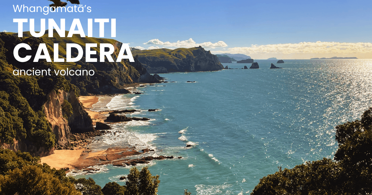
Just south of Whangamatā, where the coastline begins to feel wilder and more rugged, there’s a story written not in words, but in rock. Most visitors see dramatic cliffs, scattered offshore islands, and hidden sea caves. What they’re really looking at is the exposed heart of an ancient volcano — the remains of the Tunaiti Caldera.
A landscape born from fire
Around 7 million years ago, this peaceful stretch of coastline was anything but calm. The region sat within the highly active Coromandel Volcanic Zone — a chain of volcanoes constantly erupting, reshaping the land. Here, a large volcano began building itself over time, layer by layer. Thick flows of lava — andesite and dacite — spread across the landscape, forming the foundation of what would become something far more dramatic. Then, everything changed.
The collapse that shaped a coastline
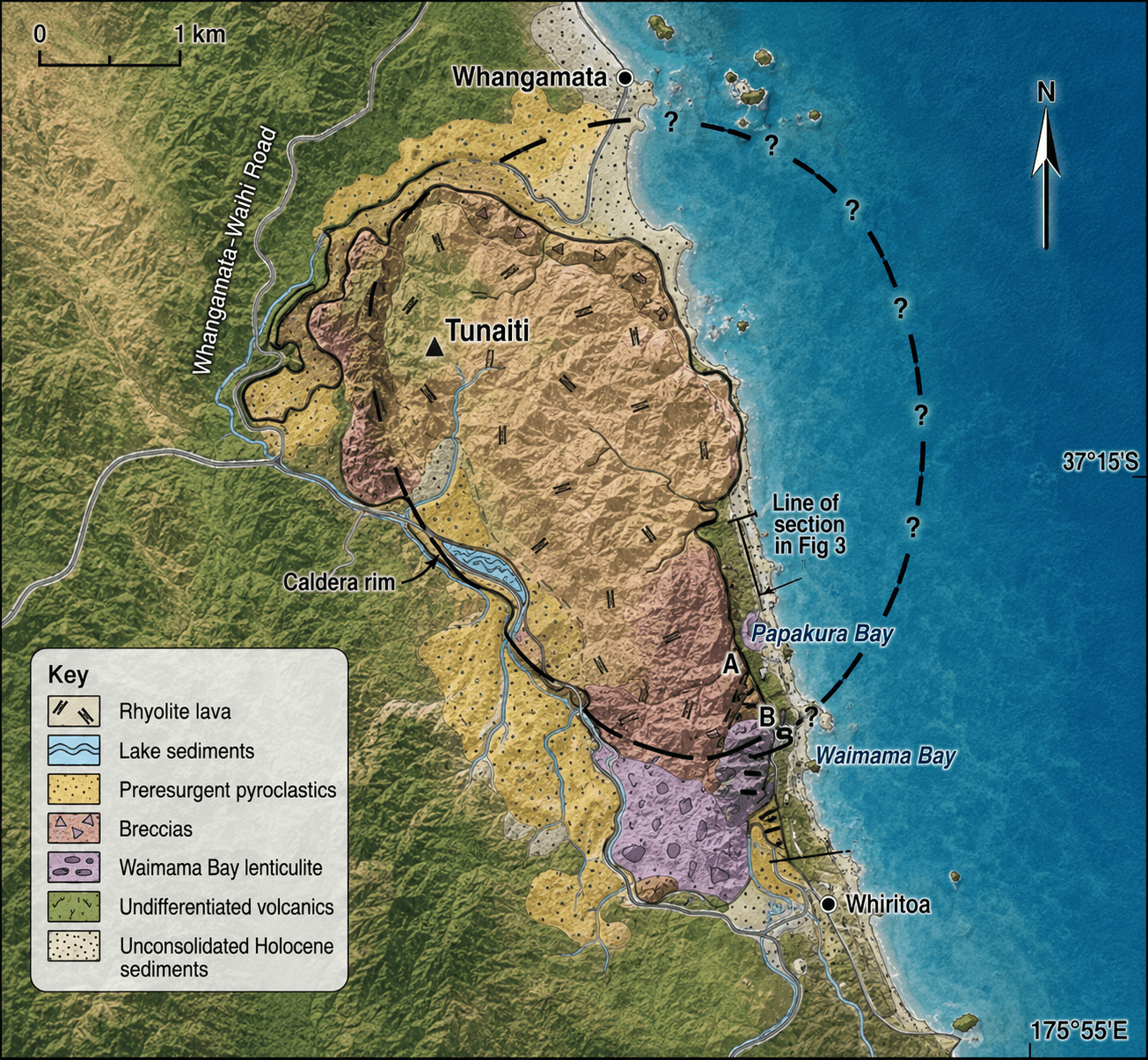
At some point, the volcano erupted with such force that it emptied its own magma chamber. With nothing left to support it, the ground above collapsed inward, creating a विशाल volcanic basin — a caldera. Imagine the land sinking in on itself, fracturing, folding, and breaking apart. Ash clouds filled the sky. Superheated flows of gas and rock surged across the terrain, leaving behind thick layers of welded volcanic material. This was the birth of the Tunaiti Caldera — a massive geological event that would define the coastline we see today.
A hidden world inside the caldera
But the story didn’t end with collapse.
Over time, the caldera became a basin — a sheltered environment where lakes formed and sediments settled. Broken rock from the collapsing walls created chaotic breccias, while fine volcanic ash layered quietly in the water.
 Then, deep below the surface, pressure began to build again.
Magma pushed upward, slowly lifting parts of the collapsed caldera floor in a process known as resurgence. This created bulbous rhyolite domes and complex ներ՚ rock formations — many of which now form the cliffs and headlands along this coast.
These formations are why the area feels so different from a typical sandy shoreline. Every cliff face, every jagged outcrop tells part of this volcanic story.
Then, deep below the surface, pressure began to build again.
Magma pushed upward, slowly lifting parts of the collapsed caldera floor in a process known as resurgence. This created bulbous rhyolite domes and complex ներ՚ rock formations — many of which now form the cliffs and headlands along this coast.
These formations are why the area feels so different from a typical sandy shoreline. Every cliff face, every jagged outcrop tells part of this volcanic story.
The final breaths of a volcano
In its later stages, the volcanic system changed character. The eruptions became smaller, more focused. Rhyolite dikes cut through the rock like veins, and eventually, quieter dacite eruptions marked the fading energy of the system. The volcano that once dominated this region slowly went silent. What remained was a fractured, uplifted, and incredibly complex landscape — a geological time capsule.
The coastline as a natural cross-section
Fast forward millions of years, and the ocean has done something remarkable. Wave by wave, storm by storm, the sea has carved into the land — cutting directly through the ancient caldera. What you see today is essentially a cross-section of the volcano’s interior, laid bare along the coastline between Whangamatā and Whiritoa. It’s rare. In most places, volcanoes are hidden beneath vegetation or eroded beyond recognition. Here, the structure is exposed in stunning detail — from lava flows and ash layers to collapsed rock and resurgent domes.
A story you can paddle through
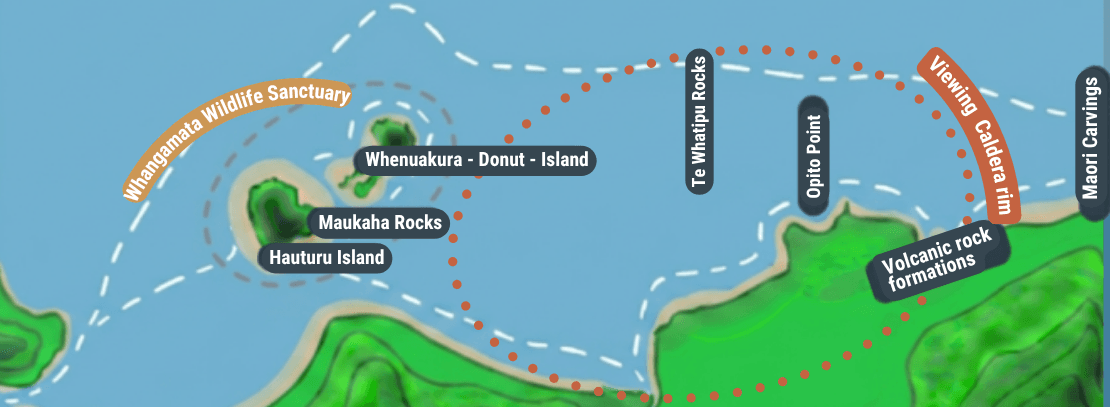
For those exploring this coast by kayak or boat, the experience becomes something deeper than just scenery. As you move past sea caves and towering cliffs, you’re tracing the edges of an ancient volcanic basin. Islands like Whenuakura (Donut Island) sit within this wider volcanic system — remnants of the same fiery past. The calm waters, the echo inside caves, the towering rock walls — they all exist because of events that happened millions of years ago beneath your feet.
More than just a view
Understanding the story of the Tunaiti Caldera changes the way you see this coastline. It’s no longer just beautiful — it’s alive with history. Every paddle stroke, every glance at the cliffs, becomes a journey through time. From explosive eruptions to silent erosion, from collapse to resurgence, this landscape holds the memory of a volcano that once shaped the region. And today, it offers something rare: the chance to experience the inside of an ancient volcano — not from above, but from within.
Our Discover Whangamatā Boat Tour gives visitors a unique perspective of the Tunaiti coastline — combining local storytelling, scenic exploration and adventure into one unforgettable experience.
Guests often discover:
- Hidden rock formations only visible from the ocean
- Crystal-clear water around volcanic reefs
- Coastal wildlife and birdlife
- Secret beaches and sea caves
- Panoramic views back toward Whangamatā Beach and surrounding hills
The tour is designed for travellers wanting more than just sightseeing. It is an opportunity to connect with the natural history and raw beauty of the Coromandel coast.